Trail Nepal
Duration
13-14 Days
Difficulty
Challenging
Elevation
5,357m
Best Season
March-May
Starting Point
Kathmandu

Trek Overview

Everything you need to know about the journey

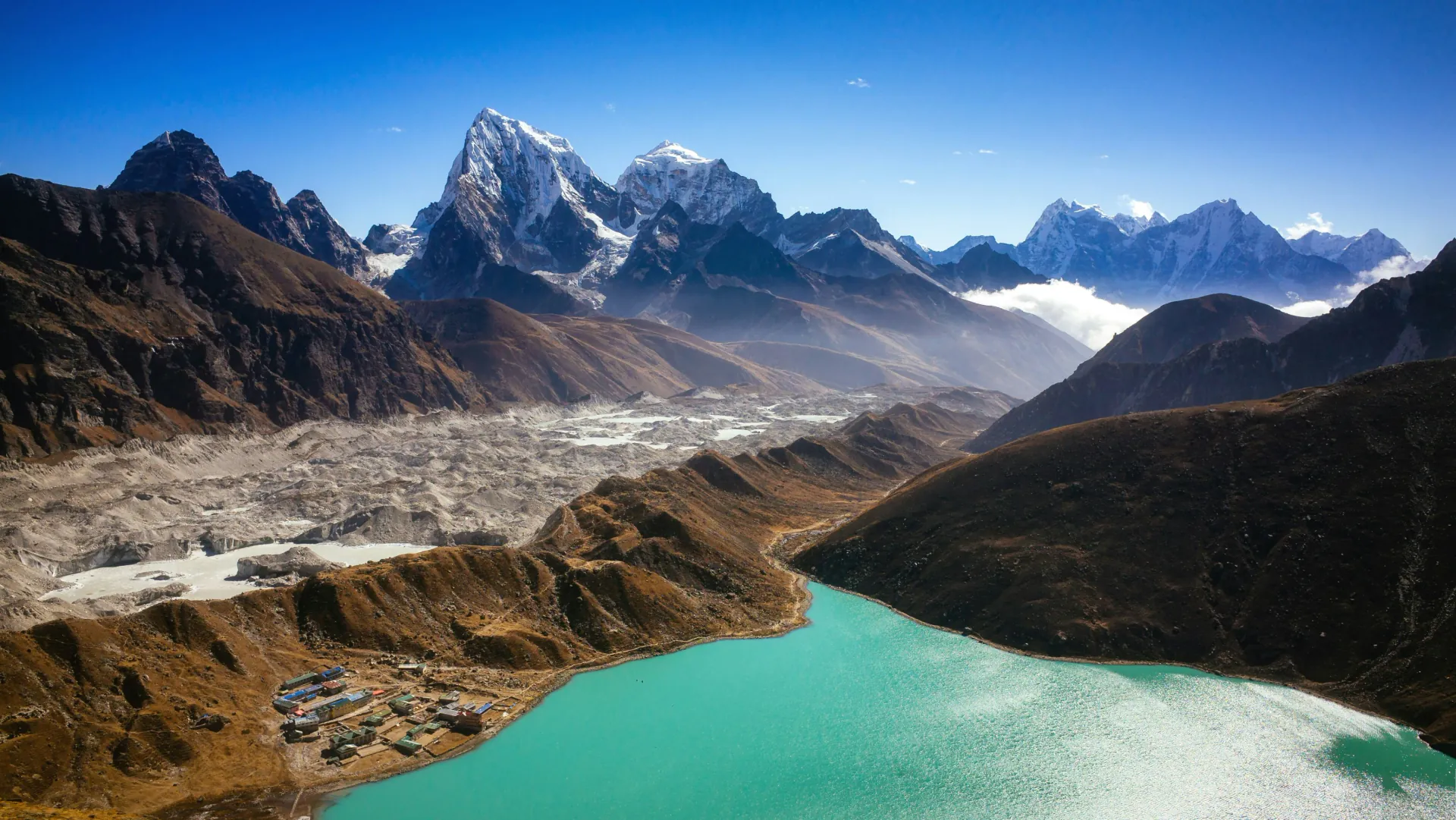
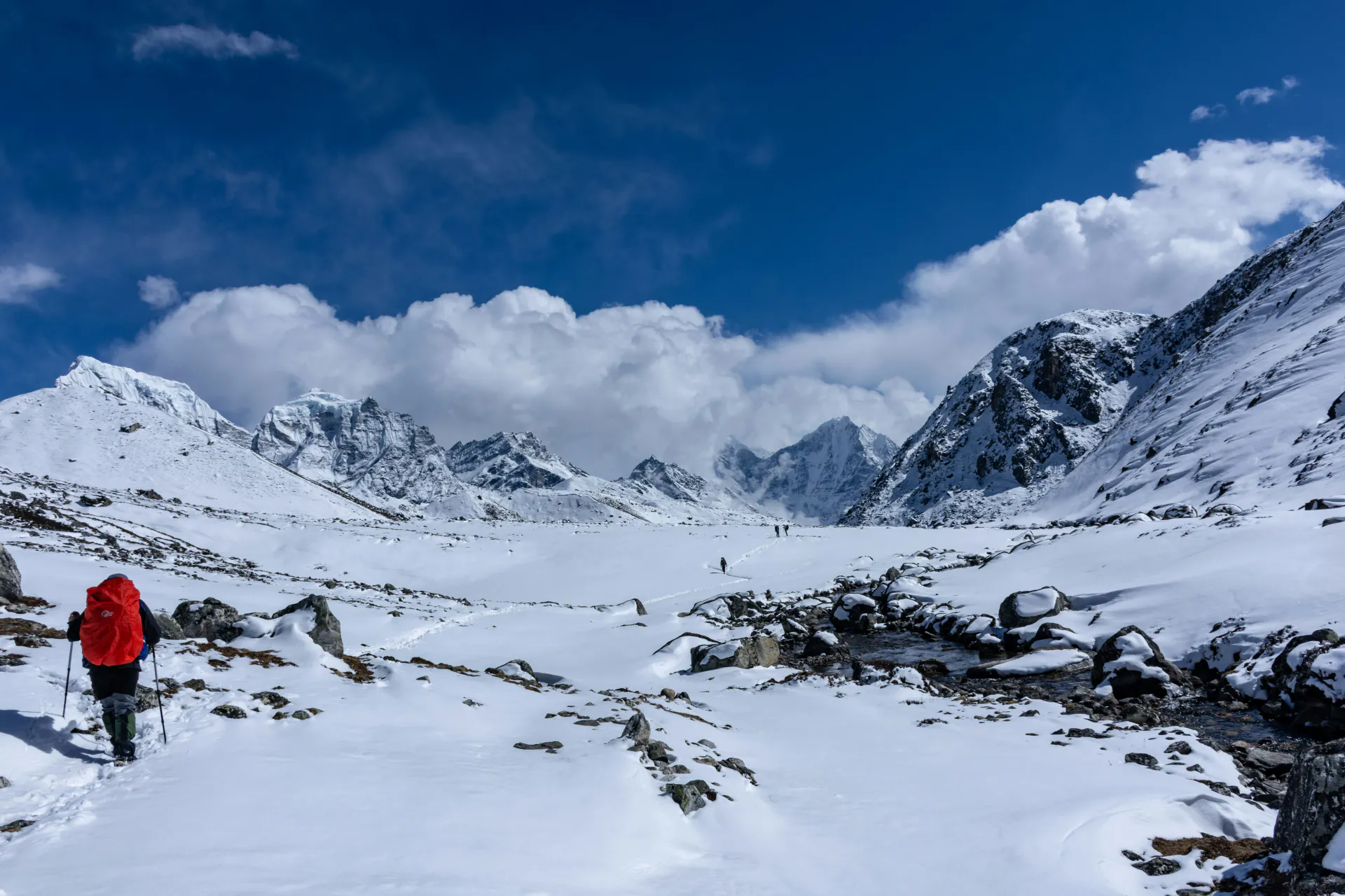
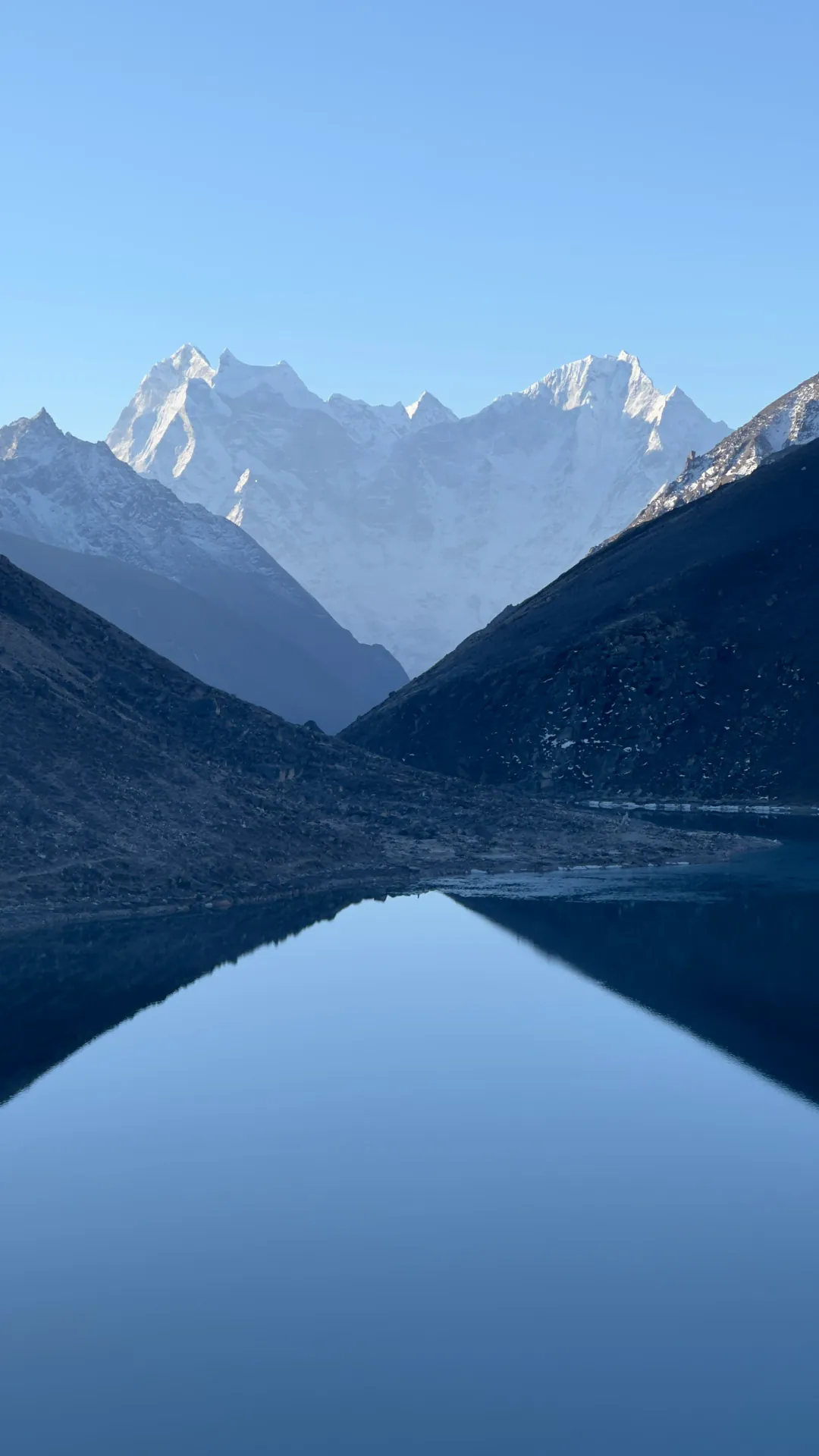
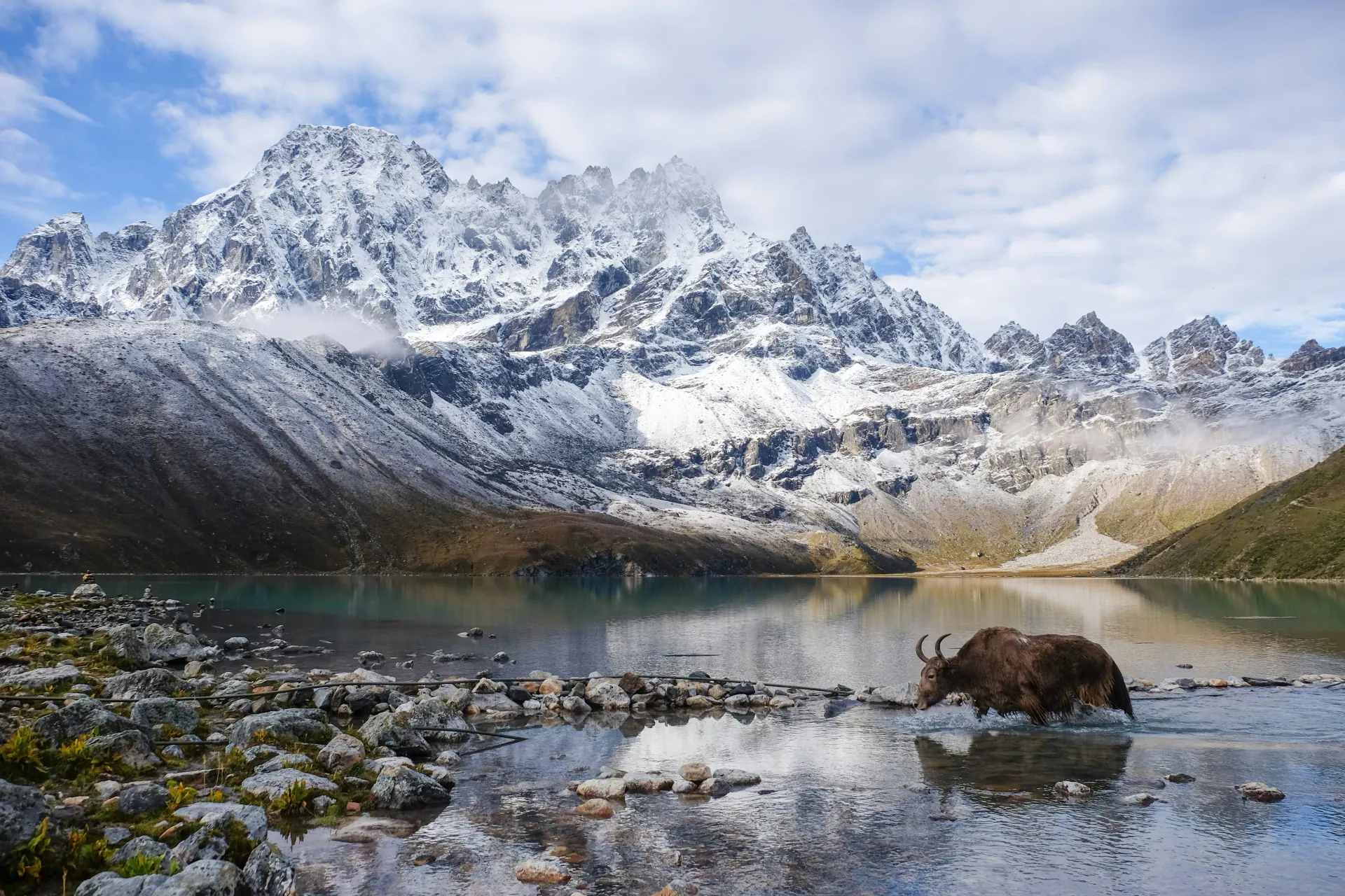
The Gokyo Valley is the Khumbu's better-kept secret. It shares a flight into Lukla and a walk through Namche Bazaar with the Everest Base Camp trek, then quietly peels away northwest at Kyanjuma and climbs toward a world that most Khumbu trekkers never see: high-altitude glacial lakes burning turquoise against a backdrop of ice and rock, Nepal's longest glacier spreading across the valley floor like a slow river of rubble, and a viewpoint at Gokyo Ri (5,357m) that many experienced trekkers argue is superior to Kala Patthar. From the summit of Gokyo Ri you see four 8,000m peaks simultaneously: Everest, Lhotse, Makalu, and Cho Oyu arranged across the horizon with the Ngozumpa Glacier directly below and the string of Gokyo Lakes glittering in the valley you just climbed through. It is a panorama that rewards the extra days and extra effort it takes to reach it. What separates Gokyo from EBC is the quality of solitude and the character of the landscape. Above Dole, the valley narrows, the trail empties, and the terrain shifts from forest and suspension bridges to alpine meadow, glacial moraine, and high-wind ridgeline. The six Gokyo Lakes designated a Ramsar Wetland Site in 2007, the world's highest freshwater lake system are sacred to local Sherpa communities and have a stillness that EBC's tent-city atmosphere cannot offer. Only around 35% of Khumbu trekkers take this route. That gap shows on the trail above Machhermo you may walk entire mornings without passing another group.

When Should I go?

Climbing windows for Trek regions.

PEAK
DANGER
CAUTION
JAN
Heavy Snow Above 4,000m
FEB
Cold & Icy
MAR
Spring Begins
APR
Stable Weather
MAY
Warm & Clear
JUN
Monsoon Builds
JUL
Full Monsoon
AUG
Peak Monsoon
SEP
Late-Monsoon
OCT
Crystal Clarity
NOV
Excellent Visibility
DEC
Very Cold Above 4,000m

What to Expect

Understand rhythms before you go

Gokyo Valley Trek expectations

The Gokyo Valley is the Khumbu's better-kept secret. It shares a flight into Lukla and a walk t...”

Four 8,000m Peaks from One SummitGokyo Ri at 5,357m is the only viewpoint in Nepal from which Everest, Lhotse, Makalu, and Cho Oyu are all visible simultaneously, a four-peak panorama that the more famous Kala Patthar viewpoint on the EBC route cannot match.

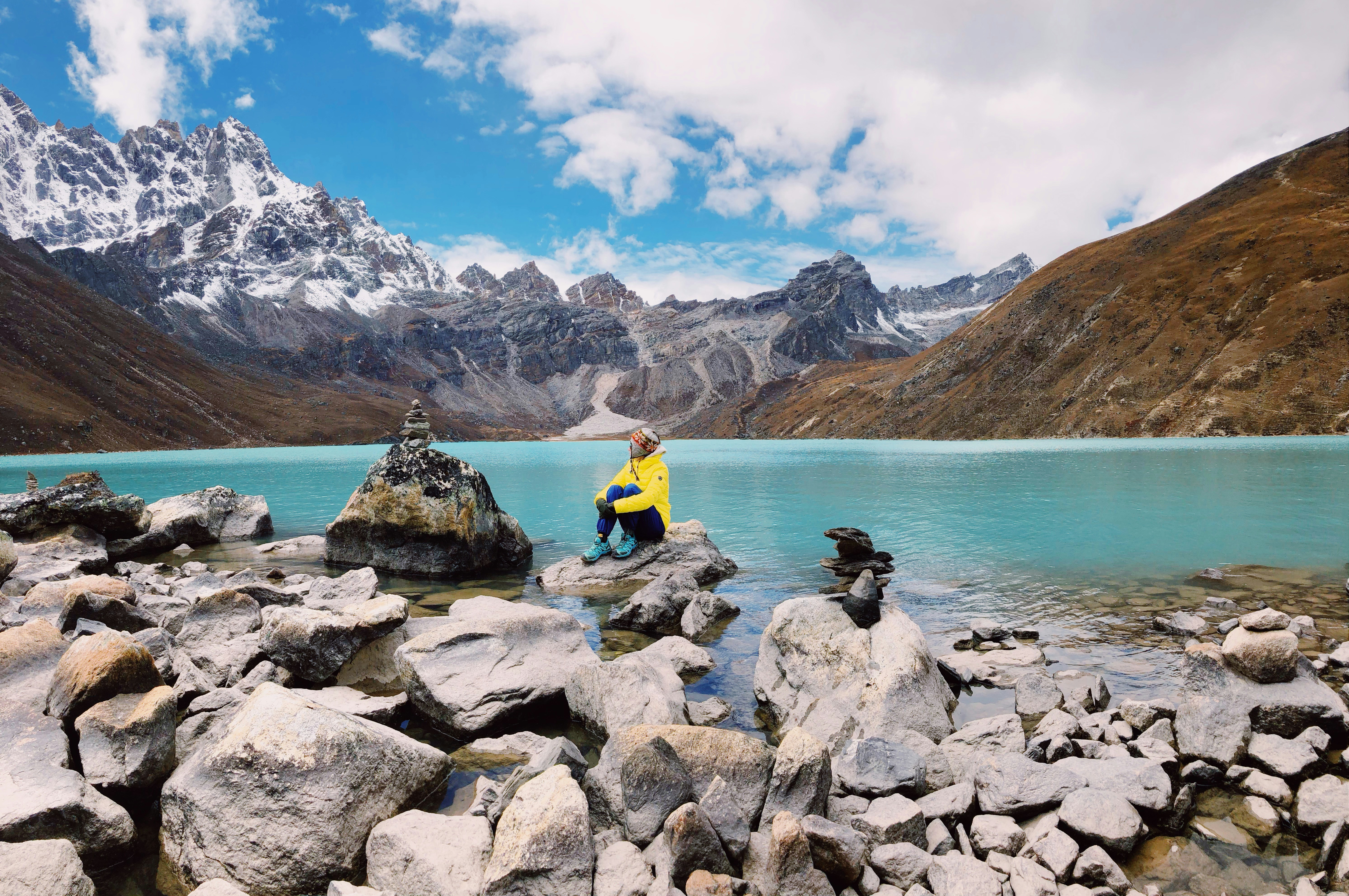
The Gokyo LakesSix glacial lakes ranging from 4,700m to 5,000m, designated a Ramsar Wetland Site in 2007 and considered sacred by Sherpa communities. The Third Lake (Dudh Pokhari) reflects Cho Oyu and the surrounding peaks in conditions that make photography feel almost unfair. The Fifth Lake, tucked in a remote bowl near Cho Oyu Base Camp, offers high-altitude solitude that is increasingly rare in the Khumbu.

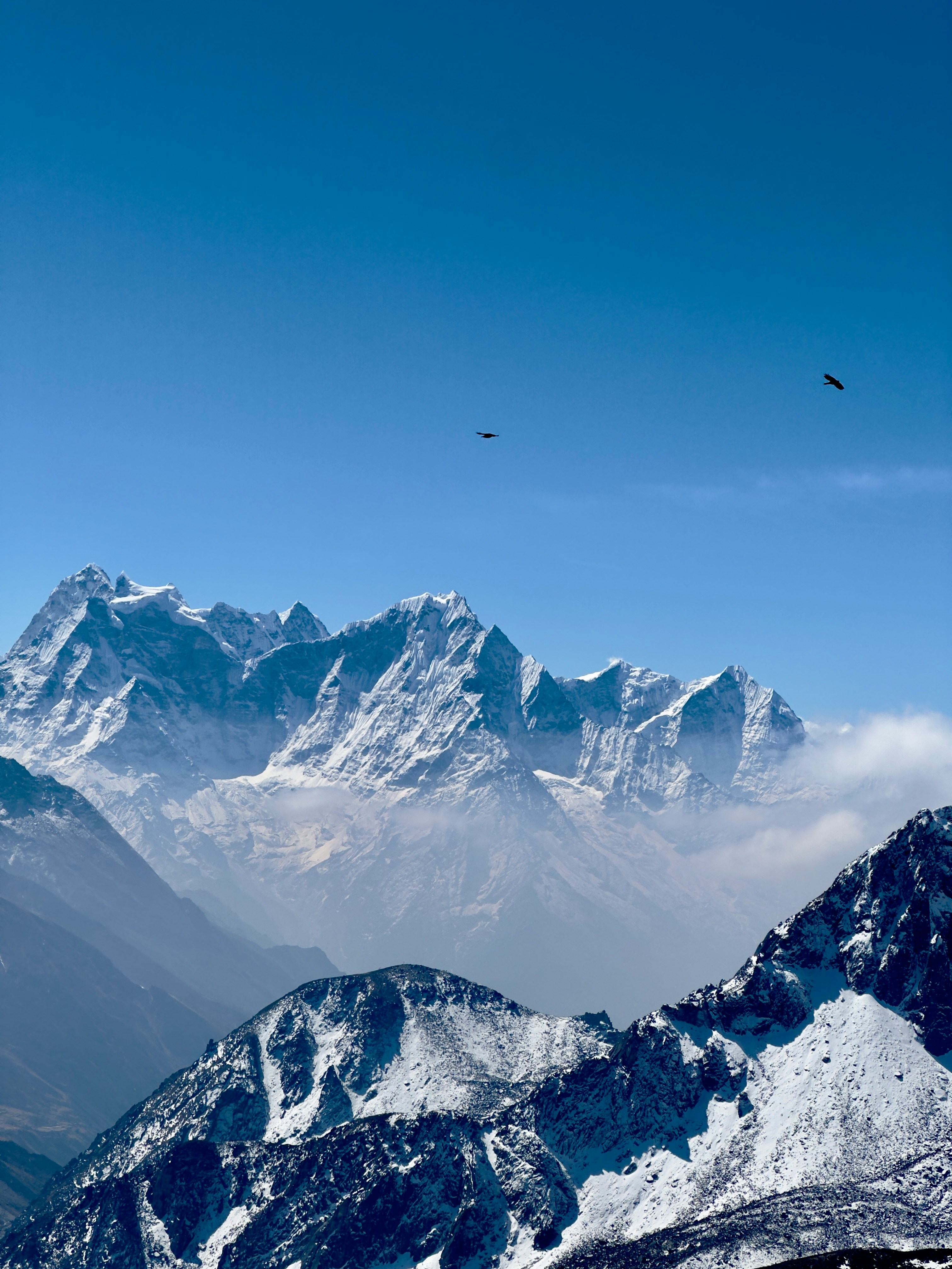
The Ngozumpa GlacierNepal's longest glacier at over 36km, visible from the valley floor as a vast grey river of ice and rock debris stretching from Cho Oyu toward Gokyo. Walking alongside the terminal moraine on the approach to Gokyo is one of the most dramatic pieces of trail in the Khumbu region and a visceral illustration of how quickly this glacier is retreating.

The Khumbu Without the CrowdsAbove Dole the Gokyo trail sees roughly 35% of EBC's trekker numbers. Above Machhermo that thins further. The lakes, the glacier, and the summit of Gokyo Ri carry the same mountain pedigree as anything on the EBC route without the queue.

Altitude & Safety

Comprehensive health guidance and immediate response tools for the high altitude trekker.

What it is?

Acute Mountain Sickness (AMS), often called High Altitude Sickness, occurs when your body doesn't have enough time to adjust to lower oxygen levels at higher elevations. It is a natural physiological response, but one that demands immediate attention and respect. Think of it as your body's signal to slow down and breathe.

Symptoms

HeadacheHeadache
Rapid heartbeatRapid heartbeat
BreathlessBreathless
DizzinessDizziness
InsomniaInsomnia
FatigueFatigue
No appetiteNo appetite
NauseaNausea

Severity Levels

mild

Rest at current altitude. Do not ascend further until symptoms clear.

moderate

Immediate descent required (300-500m). Use oxygen if available.

severe

Life-threatening. Immediate emergency evacuation via helicopter.

Prevention Tips

  • Ascend slowly (no more than 300-500m per day above 3,000m)
  • Stay hydrated (3-4 liters per day)
  • Avoid alcohol and sleeping pills
  • Eat light, high-carb meals
  • Listen to your body and rest when needed

What it is?

High-altitude pulmonary edema (HAPE) is a dangerous build-up of fluid in the lungs caused by altitude-related low oxygen, not by heart failure. It usually appears 24-96 hours after a rapid ascent, often above about 2,400 m, and it can occur with or without AMS. Early diagnosis matters because HAPE can progress quickly and may be more rapidly fatal than HACE.

Symptoms

Chest congestionChest congestion
Rapid heartbeatRapid heartbeat
BreathlessBreathless
Dry CoughDry Cough
Blue LipsBlue Lips
Energy lessEnergy less
Rapid breathingRapid breathing
Breathless at restBreathless at rest

Severity Levels

Possible HAPE

Cough, chest tightness, unusual breathlessness on exertion, or a sudden drop in walking performance after ascent.

Probable HAPE

Breathlessness with mild activity, marked fatigue, rapid breathing, crackles/rales, or clearly reduced oxygen saturation compared with others at the same altitude.

Severe HAPE

Breathlessness at rest, respiratory distress, cyanosis, or pink/bloody sputum.

Prevention Tips

  • Ascend gradually.
  • Once above 3,000 m, increase sleeping altitude by no more than about 500 m per night.
  • Add an extra acclimatization night for every 1,000 m of sleeping-altitude gain.
  • Avoid overexertion during the first 48 hours at altitude.
  • Known HAPE-prone trekkers may need preventive medication from a clinician familiar with altitude medicine.

What it is?

High-altitude cerebral edema (HACE) is a severe altitude illness in which the brain swells. It is generally considered the end-stage of AMS and is defined by neurologic symptoms, especially altered mental status and ataxia. It is rare, especially below about 4,300 m, but once it starts it can deteriorate rapidly to coma within hours if untreated.

Symptoms

Severe HeadacheSevere Headache
DrowsinessDrowsiness
ConfusionConfusion
Loss of coordinationLoss of coordination
Unsteady walkingUnsteady walking
Altered behaviorAltered behavior
StuporStupor
Coma in late diseaseComa in late disease

Severity Levels

Possible HACE

A trekker at altitude develops a severe headache plus confusion, unusual behavior, or clumsy walking. Action: Treat as HACE until proven otherwise. No further ascent. Start descent urgently.

Probable HACE

Clear ataxia, altered mental status, marked drowsiness, or difficulty walking normally. Action: Immediate descent, oxygen if available, and dexamethasone if trained and equipped to use it.

Severe HACE

Stupor, inability to walk, or coma. Action: This is a life-threatening emergency. Immediate evacuation is required. If descent is not feasible right away, oxygen and a portable hyperbaric device can be lifesaving.

Prevention Tips

  • Ascend gradually and avoid going too high too fast.
  • Once above 3,000 m, limit sleeping-altitude gain to about 500 m per night.
  • Add an acclimatization day for every 1,000 m of sleeping-altitude gain.
  • Do not ascend with worsening AMS symptoms.
  • Dexamethasone is used mainly for treatment or emergency backup, while acetazolamide is preferred for prevention of AMS during ascent.
5,357mHigh risk above 4000m

Maximum altitude: Gokyo Valley Trek

High risk of altitude sickness beyond 4,000m.
Proper acclimatization is non-negotiable.

Reach Out To

Specialist Hospitals

CIWEC Hospital01-4424111 (0),01-4435232,01-4413163
Star Hospital01-5550197/8,01-5540478

Helicopter Rescue

Heli Everest Serviceinfo@heli.everest
01-4112299, 9851111187Dabur Building (4th floor)
Mountain Helicoptermountainheli@wlink.com.np
01-4111031, 9851037407
Altitude Airaltitude@altitudeheli.com
01-4116665
Simrik Airinfo@simrikair.com.np
01-4155341, 9851010696
Fishtail Air Pvt Ltd
01-4112206(17, 30), 01-4112463(64, 65, 66, 67), 9751000120, 9851026185
Air Dynastyinfo@airdynasty.com
01-4497418, 01-4468802, 9851023104Sinamangal
Shree Airlines Pvt. Ltdshreeair@shreeair.com
01-4222948Tripureshwor
Helicopter Rescue Service
01-4418824, 9851035514Naxal
Sumeru Hospitalsumeruhospital@sumerugroup.org.np
01-5003377, 01-5003388, 01-5003399, 9802003377, 9802003388Dhapakhel
Alka Hospitalinfo@alkahospital.com
01-5555555, 01-5544477, 01-5535147Jawalakhel
Norvic Hospitalinfo@norvichospital.com
01-4258554Thapathali
Vayodha Hospitalinfo@vayodha.wlink.com.np
01-2111333, 01-4281666, 01-4286428Balkhu

Carry this on your Trek

Download this offline altitude safety card before trek. Includes AMS, HAPE, and HACE symptoms and preventions.

Download Safety Card

Gear Checklist

Make sure you have everything you need

Progress0 / 32 Items

Weight: 0.0 kg

Essential

0 / 20 packed

Critical items required for safety, comfort, and completing your trek.

1.50kg
0.08kg
0.42kg
0.34kg
0.34kg
0.20kg
1
0.42kg
3
0.63kg
2
1.10kg
0.18kg
3
0.07kg
0.06kg
0.07kg
0.47kg
0.10kg
0.13kg
0.03kg
0.10kg
0.28kg
0.15kg
a vertical image with a snow-capped mountain and its reflection
Snowy trails
Nestled between a large turquoise glacial lake, and an actual glacier right behind it.
Gokyo
Gokyo
Gokyo